


 |
||||||||||||||||||||||||||||||||||||||||||||||||
| Day 3: Graveyard Creek to Teco Lake
Emerging from the tents we were greeted by thick, white frost covering the ground, tents and any item that had been left out overnight. But, the sky was bright blue, promising us sunshine and warmth. |
||||||||||||||||||||||||||||||||||||||||||||||||
 |
||||||||||||||||||||||||||||||||||||||||||||||||
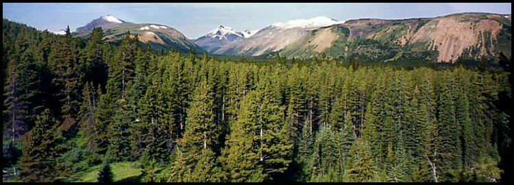
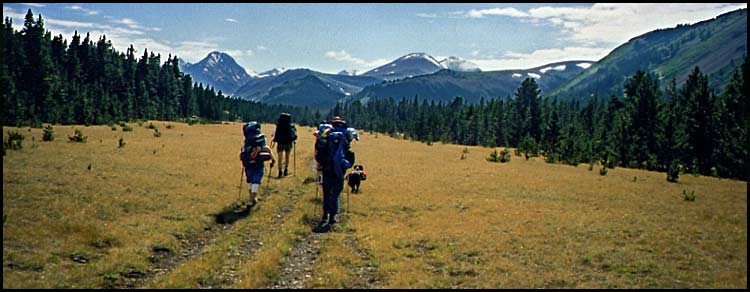
| Looking at the treeline just above our camp to the wonderfully smooth, rolling mountains so typical of the Chilcotin. Although we didn't know it yet, Day 4 would see us day hiking over the bare mountain at left, up the small patch of snow to the tip of the peak. For possible references sake later on, in case you're so interested, the velley at center cutting between the two hills is Tosh Creek. | ||||||||||||||||||||||||||||||||||||||||||||||||
| As we packed and ate breakfast, Joanne related to us the amazing night she'd had. She got up at 3:00am to find the entire meadow drenched in the light of full moon and had to restrain herself from waking us up to marvel at the sight. A little later, but still very early, her tent came under physical assault by either a moose or more likely a deer as it galloped top speed at and into her tent before crashing off into the bushes! Perhaps it had been spooked by Robson's scent??
We departed camp at 8:30, deciding to follow the distinct path that led through the meadow and curved around a slope following the creek. Feeling confident that now we were on the right trail on the east side of Big Creek, we pushed on in good cheer. |
||||||||||||||||||||||||||||||||||||||||||||||||
 |
||||||||||||||||||||||||||||||||||||||||||||||||
| About 10 minutes after leaving camp (just around the corner), we paused for a photo opportunity along what we thought was Big Creek (actually Graveyard Creek) | ||||||||||||||||||||||||||||||||||||||||||||||||
| Confusion Abounds
Not soon after the photo was taken did the trail end abruptly. We climbed up the slope fifty feet, set our packs down and had an hour long orienteering session with maps and compass. Consensus was we were not on Big Creek after all, but on Graveyard Creek or possibly even one it's tributaries. We hiked down to the creek, crossed it, hiked up a steep embankment on the opposite side to a ridge where we gained a slightly better view of the vast Big Creek valley. Whoa. We had a ways to go. Making our way down from the ridge we stumbled onto the widest path we'd seen yet - according to our map it would be the Graveyard Creek trail. We followed it downhill for a good 45 minutes, happy for the quick time the trail was allowing us to make. We came to the edge of Big Creek, but were confused not to find a junction with the trail on its east side that would lead us upstream. We folloed the trail as it turned a sharp right and followed it downstream instead. We deduced this must be Graveyard Creek, but thick confusion was setting in. We eventually did come to a sharp Y-intersection where an abrupt left turn would lead us to the creek. Just to make sure of where we were, Andre decided that he would run downstream along the trail to see if it lead back to the "Jeans Cabin". He grabbed map, compass, bear spray and 2-way radio by which we kept in contact over the next hour. He ran top speed over trail, through bush, cross creek after creek until he came to the confluence of Tosh Creek and Big Creek. Finally joining up with us, we took the other fork and almost right away found ourselves being led to the edge of a wide creek which we could see continuing on its opposite shore. |
||||||||||||||||||||||||||||||||||||||||||||||||
 |
||||||||||||||||||||||||||||||||||||||||||||||||
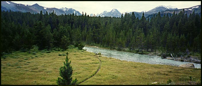
| The tail leads to the shore of Big Creek, continuing on its opposite shore. The wedge shaped mountain at center pictures very prominently in our photos over the course of this day and days 4 - 6. It rises up high from the shores of spectacular Lorna Lake - one of our main destinations along this trip F(we'd actually planned to arrive at Lorna Lake by day 3). | ||||||||||||||||||||||||||||||||||||||||||||||||
| Crossing Big Creek
Having believed the trail upstream we'd just followed was the eastern Big Creek trail, we now revised our belief that this was Graveyard Creek and would encounter the right trail once across. (The map does show a crossing over Graveyard Creek) It's amazing what you can lead yourself to believe. So, we made our way across through the icy water. As Ashley and I both had fairly vulnerable, fleshy, oozing toe wounds, Andre helped us across. |
 |
|||||||||||||||||||||||||||||||||||||||||||||||
 |
||||||||||||||||||||||||||||||||||||||||||||||||
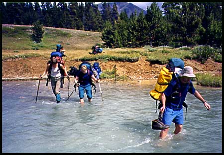
| Joanne, Aynslie and Ian make their way across while a couple packs wait on shore for Andre to transport. | ||||||||||||||||||||||||||||||||||||||||||||||||
| Our Sherpa
As you can see by the photos, the water is not exactly shallow and was relatively swift. Andre's 6'3" and look where the water comes to on him. He first gave me a lift across (I'd come close to breaking my toe while scouting for Cinnabar trail before we'd even began hiking, leaving me without several layers of skin and a severely bruised "fungus nail"), then went back for my pack. Then back for Ashley who's even two inches taller than Andre. (Ashley had sliced the flesh from the bottom of his big toe almost completely off on one of his boot lace cleats while climbing into the tent the previous night). And back one again for Ashley's pack. Then back for his own pack and one last time for Sarah's pack. That's twelve trips across the creek - barefoot! I kinda' think I married the right guy! |
||||||||||||||||||||||||||||||||||||||||||||||||
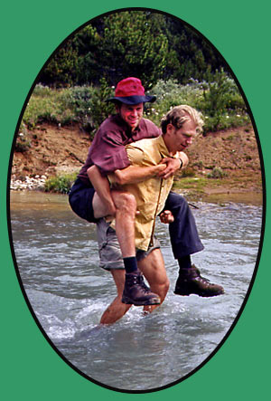
| Now that's brotherly love!! | ||||||||||||||||||||||||||||||||||||||||||||||||
| Feet dried off and packs firmly adjusted (unbuckled for the crossing), we walked through the small pine forest emerging onto a vast wide plain. Three good paths all side-by-side (made by horses) assured us we were definitely on the right track. Just to make sure, the three guys dropped their packs and ran through the trees at our right to see if indeed Big Creek was flowing at our right. Coming back with news of the creek, we proceeded onwards, not realizing until much later that what they'd seen was Tosh Creek.. | ||||||||||||||||||||||||||||||||||||||||||||||||
 |
||||||||||||||||||||||||||||||||||||||||||||||||
| Hiking up Big Creek valley, the ever-present wedge mountain looming at the headwaters of the creek. L-R: Sarah, Joanne, Ashley, Robson | ||||||||||||||||||||||||||||||||||||||||||||||||
| Travelling at a good pace despite the heat, we soon began a slight ascent through forest. Only when the trail made an abrupt left turn and began ascending steeply did I get a sense we were not where we thought we were. Another map and scouting session ensued, this time Ian followed Andre. They came back with news of a wide valley and braided creek far below us. As we continued and gained the view for ourselves, I recoginzed it to be Big Creek from photos I'd seen while researching the trip. There it was below us - to our left. At this point we realized the creek we'd crossed was indeed Big Creek and that the one the three guys had scouted had been Tosh Creek.
If this all sounds highly confusing - it is. It took us days to straighten out exactly what was where! Camp at Teco Lake The acent took us to a small pass and a beautiful campsite next to a small lake. Now knowing for certain where we were, we broke for camp at this ideal spot. The lake was no good for washing or gathering water from - even if we were filtering. Though wide, it was only perhaps two feet deep and rather swampy looking. Water access was the only drawback of this camp: the outflow of the lake was a mere trickle and it took an eternity to fill our water bladders and bottles. Fortunately, Andre and I packed along a folding 6-litre "camp size" bladder which made a perfect collection bag to then filter from at camp into our smaller containers. |
||||||||||||||||||||||||||||||||||||||||||||||||
 |
||||||||||||||||||||||||||||||||||||||||||||||||
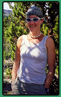
| Joanne finds herself cornered by my camera | ||||||||||||||||||||||||||||||||||||||||||||||||
 |
||||||||||||||||||||||||||||||||||||||||||||||||
 |
||||||||||||||||||||||||||||||||||||||||||||||||
| On the map the lake is unnamed, but this sign seemed kind of official... | ||||||||||||||||||||||||||||||||||||||||||||||||
 |
||||||||||||||||||||||||||||||||||||||||||||||||
| Dusk at Teco Lake. The wedge-shaped mountain getting a little closer. | ||||||||||||||||||||||||||||||||||||||||||||||||