


 |
||||||||||||||||||||||||||||||||||||||||||||||||
| North Vancouver to Banff - yes, that's clear across the province. And the most mountainous province in Canada at that - flat roads are basically unheard of: you're either going up or down.
Our route was roughly 1,200 km's snaking our way north and south, then north and south again and again. We wanted to stay on back roads, preferably gravel roads for as much as possible. The largest stretch of unpaved roads was between Hope and Castlegar where we only touched pavement for small connecting sections totalling perhaps 80 km's. Having cycled the full length of Kettle Valley Railway twice before (including the branch from Spences Bridge and the Brookmere area), we opted out of a few of the sections for the ease and speed of pavement (i.e.: we caved in to luxury). We axed the Princeton to Summerland section, and the sections between Idabel Lake and Midway, and Midway to Eholt. Okay, so we also didn't ride the Grand Forks to Christina Lake leg, but we did ride Christina Lake to Castlegar (have YOU done that stretch???? Betcha didn't even know it existed. Well, maybe you do now, but back in the '90's it was virtually unknown territory). So, here goes. The pictures aren't the wildest, but we did have some wildly long days. Usually we'd be up at the crack of dawn, ride like mad 'till around lunch, then try to get as far as possible by 7:00 or 8:00 PM. Back then it was all about miles. You do that sort of thing when your young. |
||||||||||||||||||||||||||||||||||||||||||||||||
|
Day 1: North Vancouver to Hope To get the Lower Mainland section behind us and not have to camp in Chilliwack or someplace like it, we departed home at 5:00 am. The wee hours of the morning are a peaceful and exhilarating time to ride, especially when you know it's just each others pedal power that will take you across the province, through the Rocky Mtn's to Banff, Alberta. |
||||||||||||||||||||||||||||||||||||||||||||||||
 |
||||||||||||||||||||||||||||||||||||||||||||||||
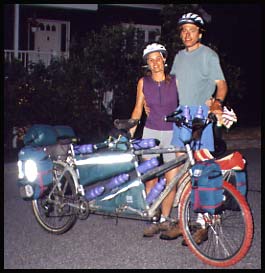
| 5:00 am departure from Kings Road, North Vancouver. And yes, all those 8 water bottles are full. | ||||||||||||||||||||||||||||||||||||||||||||||||
| 130 km's for Day 1 and we had our tent set up at the Othello Campsite 10 km's past Hope by 3:00 PM! Othello was one of the names given to the various stations along the Kettle Valley Railway (KVR). The engineer, Andrew McCulloch, was a big fan of the Bard and named many of his stations after Shakespearean characters (such as Romeo, Juliet and Lear).
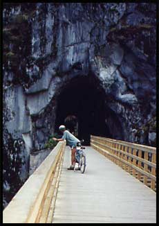
With most of the afternoon still left, we took showers at the campsite bathhouse, soaked our feet in the Coquihalla River, and took a little ride over to the famous KVR Quintette Tunnels (below), now fully decked and complete with railings. |
||||||||||||||||||||||||||||||||||||||||||||||||
 |
||||||||||||||||||||||||||||||||||||||||||||||||
 |
||||||||||||||||||||||||||||||||||||||||||||||||
| Outside one of the tunnels linked together by trestle bridges | ||||||||||||||||||||||||||||||||||||||||||||||||
| Day 2: Hope to Tulameen River
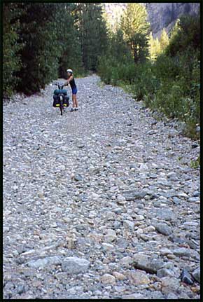
Departing the Othello Campsite, we connected with the Coquihalla Hwy and cycled up to the Boston Bar exit where we hopped onto the old gravel Pipeline Road (you used to be able to drive this to avoid the tollbooths). This is a long stretch of pretty rough road, which varies in condition from year to year. One section of it even follows along the old KVR railway bed. This year its condition had suffered from flooding: much of the lower section of road (close to the tollbooths) had become a riverbed (below), forcing us to push the bike for a lengthy stretch. |
||||||||||||||||||||||||||||||||||||||||||||||||
 |
||||||||||||||||||||||||||||||||||||||||||||||||
| Ugh, I didn't sign up for cycling riverbeds! | ||||||||||||||||||||||||||||||||||||||||||||||||
| Over a couple more mountains and we found ourselves along the Tulameen River, cycling through the small villages of Tulameen (pop.~300) and Coalmont (pop. ~100). | ||||||||||||||||||||||||||||||||||||||||||||||||
| Welcome to Coalmont, BC | ||||||||||||||||||||||||||||||||||||||||||||||||
 |
||||||||||||||||||||||||||||||||||||||||||||||||
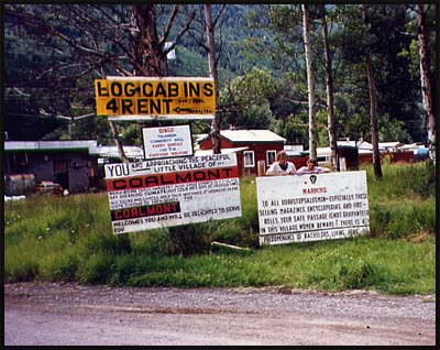
| The Signs Read: "BINGO, Tulameen Community Hall, EVERY SUNDAY, 1:30 PM, EVERYONE WELCOME"
"YOU are Approaching the Peaceful little Village of COALMONT. Population:Varies, Industries: None, Chief Sports: Sleeping and Day Dreaming, Climate: Hot-Cold-Wed-Dry at various times. All Clubs and Locales hold their meetings at midnight on the sixth Tuesday of each month....the... COALMONT welcomes you and will be delighted to serve you" "WARNING: To all doorstepsalesmen - especially those selling magazines, encyclopedias and firebells, your safe passage is not guaranteed in this village. WOMEN BEWARE: there is a predomnance [sic] of bachelors living here" |
||||||||||||||||||||||||||||||||||||||||||||||||
| Thank you for visiting Coalmont! | 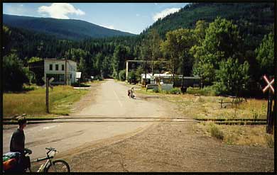 |
|||||||||||||||||||||||||||||||||||||||||||||||
| A photo of Coalmont taken in 1990 when Andre, Ian (left) and Ashley (middle) cycled through. Note the railway tracks are still intact. | ||||||||||||||||||||||||||||||||||||||||||||||||
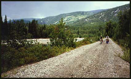
| Back on the KVR bed, we were beat and looking for a place to camp. | ||||||||||||||||||||||||||||||||||||||||||||||||
 |
||||||||||||||||||||||||||||||||||||||||||||||||
| Cyclists on the KVR bed east of Coalmont. (Actually this photo is from '93 and the two cyclists are Reimar and Ashley) | ||||||||||||||||||||||||||||||||||||||||||||||||
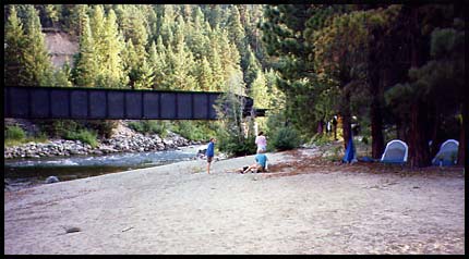
| We hoped to be able to camp at the scenic beach site we'd used in years past, but when we got there it was quite full of people who had lugged their campers in along the railway bed (now closed to vehicles except snowmobiles and ATV's). | ||||||||||||||||||||||||||||||||||||||||||||||||
 |
||||||||||||||||||||||||||||||||||||||||||||||||
| Our "usual campsite" along the Tulameen. We used this beach both in '93 (when the above photo was taken) and '94 while cycling through. | ||||||||||||||||||||||||||||||||||||||||||||||||
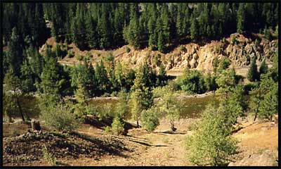
| So we had to push on. Not an easy thing to do after a long, hard day on gravel and a lot of miles behind us, but we didn't have too much choice. The landscape around us began to change shortly after leaving the beach campsite and the railway and river eventually squeezed into a narrow canyon with steep, tall slopes rising high above.
The photo at right was taken in 1990 and shows the railway (tracks intact) and river squeezing through the narrow chasm. |
||||||||||||||||||||||||||||||||||||||||||||||||
 |
||||||||||||||||||||||||||||||||||||||||||||||||
| The Tulameen and KVR squeeze through the narrow Tulameen Canyon. | ||||||||||||||||||||||||||||||||||||||||||||||||
| It was about 4pm, and quite cool and windy. We set up the tent in the shelter of some poplars, then slept for a couple hours before preparing dinner (lentil soup with cabbage and tofu wieners). | 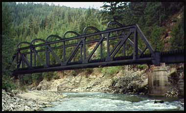 |
|||||||||||||||||||||||||||||||||||||||||||||||
| The Tulameen River and an old KVR bridge. The tiny speck of beach at left served as our camp. | ||||||||||||||||||||||||||||||||||||||||||||||||
| Day 3: Tulameen River to Trout Creek
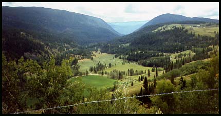
We had to carry the bike around a long section of river where the railway bed had actually been washed clean away by severe flooding (bad year...). This was a little tricky, but we pulled it off okay. From Princeton we opted out of cycling the climb up the Jura Loops and took the road instead. Nice and smooth, a luxury to be on pavement - even if it's uphill! Not much traffic, in fact, hardly a car passed by at all. Very scenic and quiet. |
||||||||||||||||||||||||||||||||||||||||||||||||
 |
||||||||||||||||||||||||||||||||||||||||||||||||
| One of the scenic views along the Princeton - Summerland Road | ||||||||||||||||||||||||||||||||||||||||||||||||
 |
||||||||||||||||||||||||||||||||||||||||||||||||
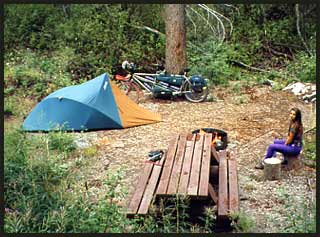
| We camped this afternoon at the Trout Creek Forest Recreation Campsite and made it there just in time to string up a tarp outside our tent from a tree and wait out a few hours of rain. The clouds passed, we took down the tarp and washed up in the small creek. | ||||||||||||||||||||||||||||||||||||||||||||||||
| Trout Creek Forest Recreation Campsite | ||||||||||||||||||||||||||||||||||||||||||||||||
| Day 4: Trout Creek to Naramata
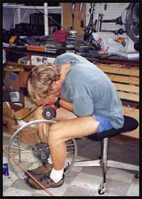
Cycling into Summerland, we noticed something not quite right with our rear wheel. Upon closer inspection it was revealed that we had a cracked rim - yikes!!! Luckily we were able to get to the famous "Bike Barn" in Penticton, and by some stroke of luck the owner happened to be able to sell us the old 48 spoke rim off his old tandem. This coincidence was beyond good fortune and saved our trip. Of course, to be able to afford the work and get it done that day, it meant Andre using their shop and doing the work himself (right). We rode to Naramata and connected with the KVR once again, where we found a small flat spot on the side of the path to set our tent for the night. |
||||||||||||||||||||||||||||||||||||||||||||||||
 |
||||||||||||||||||||||||||||||||||||||||||||||||
 |
||||||||||||||||||||||||||||||||||||||||||||||||
| Andre preps the new rim for the tandem | ||||||||||||||||||||||||||||||||||||||||||||||||