


 |
||||||||||||||||||||||||||||||||||||||||||||||||||||
| Day 5: Naramata to Beaverdell
The bike rim replaced and the weather looking like we might be in for some sun, we pushed off on the most well-known section of the Kettle Valley Railway. The railway climbs it's steepest grade on the entire line up the hills above Naramata, there is even a spiral tunnel, however now blocked off as a safety precaution. Up and up the railway climbs steadily, leaving the dry Okanagan Valley for the cooler climate of the mountains. |
||||||||||||||||||||||||||||||||||||||||||||||||||||
 |
||||||||||||||||||||||||||||||||||||||||||||||||||||
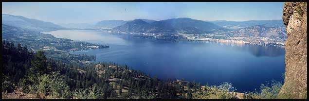
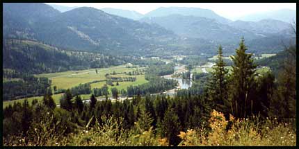
| Looking down on Okanagan Lake from the KVR. Naramata is at left, Penticton at the end of the lake, and Summerland lies to the right. | ||||||||||||||||||||||||||||||||||||||||||||||||||||
| After a few hours, the railway finished climbing and we came to Chute Lake and the Chute Lake Lodge. Andre and I first found ourselves here on our honeymoon in 1992, trying to escape the Okanagan heat. There was a campsite indicated on our map next to Chute Lake, and as it turns out there is this log fishing lodge as well. The lake itself is okay, but not good for swimming so it didn't interest us too much. They did have showers we could use, so that did interest us! | 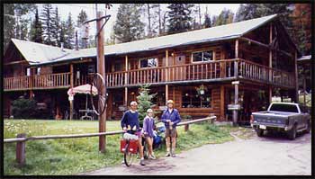 |
|||||||||||||||||||||||||||||||||||||||||||||||||||
| Andre, Trudel and Ashley standing outside the Chute Lake Lodge in 1993 | ||||||||||||||||||||||||||||||||||||||||||||||||||||
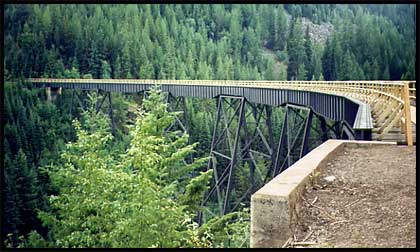
| The Kettle Valley Railway Trestle Bridges
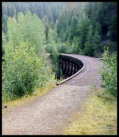
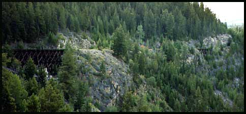
About an hours ride past Chute Lake, the world-famous KVR trestle bridges begin. There were 18 in total, along with 2 tunnels. The two tallest (also the longest), spanned West Fork and East Fork Canyon Creeks. When we came here by car in 1992 and by bike in 1993 the bridges had not yet been decked for recreational use. There was much timber missing, which made crossing extremely dangerous and impossible to cross in a car. In 1993 we did manage to get the bikes over the 10-foot long gaps by balancing along the metal bridge supports - with a casual 260-foot drop below! After a few fatalaties, the bridges were decked and tall railings put up. Unfortunately, all but two bridges were completely destroyed in the vicious Okanagan Mt.Park fire of 2003. Massive funding efforts are underway to re-span the missing gaps, but a major part of BC's history has been lost. Below is a collection of photos of the trestles taken over a number of years. |
||||||||||||||||||||||||||||||||||||||||||||||||||||
 |
 |
|||||||||||||||||||||||||||||||||||||||||||||||||||
| Photo taken in 1993. It shows two tiny bridges and a small tunnel opening at far right. This photo depicts how this entire section of railway through the Myra Canyon was etched into the mountainside. | ||||||||||||||||||||||||||||||||||||||||||||||||||||
| Photo taken in 1993; we'd camped for the night just to the left of this bridge. | ||||||||||||||||||||||||||||||||||||||||||||||||||||
 |
||||||||||||||||||||||||||||||||||||||||||||||||||||
 |
||||||||||||||||||||||||||||||||||||||||||||||||||||
| Photo taken in 1994 just after the bridges were freshly decked. This is the West Fork Canyon Creek bridge - one of the tallest on the entire line (and the one where the most ties were missing). | ||||||||||||||||||||||||||||||||||||||||||||||||||||
 |
||||||||||||||||||||||||||||||||||||||||||||||||||||
| Photo taken in 1993 | ||||||||||||||||||||||||||||||||||||||||||||||||||||
| Photo taken in 1992 on our honeymoon before the bridges were decked. Imagine having to cross if eight or ten of the cross ties are missing leaving a giant gap!! | ||||||||||||||||||||||||||||||||||||||||||||||||||||
 |
This is a postcard where the photo is circa 1918. Pretty amazing structure, isn't it? And except for a few that were replaced by steel structures, all remaining ones were like this. | |||||||||||||||||||||||||||||||||||||||||||||||||||
 |
||||||||||||||||||||||||||||||||||||||||||||||||||||
| After Myra Canyon and its bridges and tunnels is a long, lonely stretch that winds through the mountains, eventually passing the McCulloch Lake Reservoir (named after KVR engineer Andrew McCulloch) and Idabel Lake. Back then the section of railway below Idabel Lake was pretty overgrown, so we took one of the small forestry access roads and joined with Highway 33 - a quiet downhill ride all the way to the tiny village of Beaverdell. | ||||||||||||||||||||||||||||||||||||||||||||||||||||
 |
||||||||||||||||||||||||||||||||||||||||||||||||||||
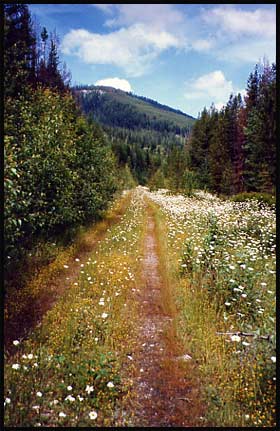
| An example of the scenic railway bed - nothing like fresh air, blue sky and fields of flowers! | ||||||||||||||||||||||||||||||||||||||||||||||||||||
 |
||||||||||||||||||||||||||||||||||||||||||||||||||||
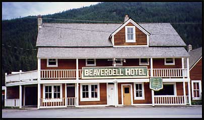
| The old Beaverdell Hotel, pretty much the main attraction in Beaverdell, other than the corner grocery store. | ||||||||||||||||||||||||||||||||||||||||||||||||||||
| Day 6: Beaverdell to Grand Forks
We'd actually camped at a campsite 25 km's south of Beaverdell, called the "Little Dipper Campsite". A nice little spot along the river that was family run. We rode mostly Hwy 33, but before it connected with the main Hwy 3, we got onto a connection of back roads and railway. In some areas the railway had been taken over by farmers, so we'd get onto farm roads and work our way along. We cycled a short stretch, about 5 km's, along Hwy 3 into the small town of Midway where there are no good connecting back roads. The railway connection wasn't great back then, though you can ridge that stretch today. I always find Midway fascinating - a small town in the middle of seemingly nowhere, surrounded in dry, golden hills. The hills look as smooth as carpet, and once we did hike up to one of the peaks pictured below. There is a quaint little KVR Railway Museum here, though it's always been closed when we've passed through. |
||||||||||||||||||||||||||||||||||||||||||||||||||||
 |
||||||||||||||||||||||||||||||||||||||||||||||||||||
| The sunny golden hills of Midway, BC | ||||||||||||||||||||||||||||||||||||||||||||||||||||
| The heat can be absolutely stifling in Midway, so we did nothing more than break for lunch and go for a quick swim in the Kettle River from the park. We pushed on up the hill, eventually cycling through the small town of Greenwood. | ||||||||||||||||||||||||||||||||||||||||||||||||||||
 |
||||||||||||||||||||||||||||||||||||||||||||||||||||
| Andre uses the tandem as a prop for stretching tight cycling hamstrings. Our front rack holds bags of clothing and a spare tire, our rear rack hold food, kitchen equipment, sleeping mats, sleeping bags (large green roll behind my seat), tent and some extra sweaters we'd just taken off piled on top. The lower frame bag holds tools, extra chain, bike pump, etc. The upper frame bag holds sunscreen, camera, snacks, and sunglasses. And the bottles? They hold beer - of course. Nothing like a coupla' drunk cyclists... (water, you fool, water!!!) | ||||||||||||||||||||||||||||||||||||||||||||||||||||
| We crested the long hill at the old train stop of Eholt. Here we got back onto the railway. The highway continues to climb (and it sees a good amount of traffic), but the railway maintains grade as it passes around a mountain and takes you out to the far reaches of the Granby Valley.
It is a long stretch of downhill along the side of the valley, and very scenic at that. The Granby River meanders through green fields and grazing livestock. |
||||||||||||||||||||||||||||||||||||||||||||||||||||
 |
||||||||||||||||||||||||||||||||||||||||||||||||||||
 |
||||||||||||||||||||||||||||||||||||||||||||||||||||
| Finally the railway led us into the back end of the town of Grand Forks; the largest town we cycle through between Penticton and Castlegar. Here we made our way to the city campground where we set up our tent, then cycled into the city center (um, like, 2 blocks away), where we bought some groceries at the Overwaitea and thoroughly enjoyed the air conditioning!
That's the one thing about cycling the old rail bed - when you follow it into a town, you always end up in the rough, industrial end of town and sometimes can feel a little uncomfortable on your big, shiny bike and in your slick (or in our case not-so-slick) cycling gear. |
||||||||||||||||||||||||||||||||||||||||||||||||||||
 |
||||||||||||||||||||||||||||||||||||||||||||||||||||
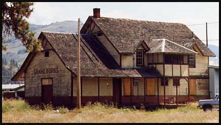
| The old KVR building at the "back end" of Grand Forks. Though now run down and boarded up, you can still see how it would have been a very attractive building in it's time. | ||||||||||||||||||||||||||||||||||||||||||||||||||||
| Day 7: Grand Forks to Nelson
This was to be our longest day of cycling on the whole journey. I don't think we set out to make it all the way to Nelson, probably we meant to camp in Castlegar. But, Nelson is "only" 50 km past Castlegar, so I think we just decided to take it in 10 km sections and "go for it". We cycled along Hwy 3 for the 21 km's from Grand Forks to Christina Lake. Normally this is a fairly busy stretch of road during the summer, but it was about 6:00 am - all the holidayers are still asleep. With no traffic, this stretch is a great ride; mostly flat with some rolling hills, nice scenery. And it's always a treat to get a stretch of pavement in after all the gravel! |
||||||||||||||||||||||||||||||||||||||||||||||||||||
| At Christina Lake we made our way up to the railway bed once again where it climbs gradually (but very noticeably on a fully loaded bike) uphill for 30 km's.
We passed by old remnants of industry along the railway, such as this coal shaft pictured at right. We crossed under the tall blue highway bridge, and soon after the grade levelled out. The pathway leads north to Lower Arrow Lake, then makes a sharp turn eastward around the mountain. From here to Castlegar it is a gradual downhill of approximately 50 - 60 km's. We had to pass through a tunnel (which we did with Ashley and Reimar back in 1993) that is over a kilometer long! And flashlights are almost useless in its depths, we had to walk the bike very carefully over the soft gravel (the gravel in most of the tunnels is extra deep) while shining the light against the tunnel wall to keep a good distance away from it. After the tunnel we began to get views of Lower Arrow Lake - a man-made lake with a dam at Castlegar. We could see the mountainside stretching on for miles and miles along the lake and could even see the thin thread of the railway cutting its way along. It was a bit of a mind-game, knowing we had to ride to beyond the far mountain before we were even close to Castlegar. |
 |
|||||||||||||||||||||||||||||||||||||||||||||||||||
| An old coal shaft alongside the railway bed above Christina Lake. | ||||||||||||||||||||||||||||||||||||||||||||||||||||
| Finally arriving in Castlegar, we rode through the town and decided it was still early enough in the day to push on for Nelson.
At this point, the bike saddles were not even remotely comfortable, in fact, it felt more like sitting on sharp rocks! We took frequent breaks, then agonized over the last stretch into Nelson trying to figure out if we were going uphill or down. It looks like downhill when both arriving at and leaving Nelson, but feels like uphill when cycling arriving. It's always confused us - anybody have the answer? Then, finally, after a loooong hard day, we arrived in the picturesque little mountain town of Nelson, situated on Kootnay Lake with its re-furbished heritage buildings and friendly home-like atmosphere. We made our way to the city campground - which affords some of the best views of the lakes to be had - and settled ourselves in for recuperation and refreshment for a few days. |
||||||||||||||||||||||||||||||||||||||||||||||||||||
 |
||||||||||||||||||||||||||||||||||||||||||||||||||||
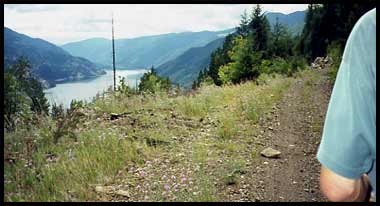
| The railway bed above Lower Arrow Lake. We had to ride beyond the far mountain at the end of the lake before even nearing Castlegar. | ||||||||||||||||||||||||||||||||||||||||||||||||||||
 |
||||||||||||||||||||||||||||||||||||||||||||||||||||
|
||||||||||||||||||||||||||||||||||||||||||||||||||||
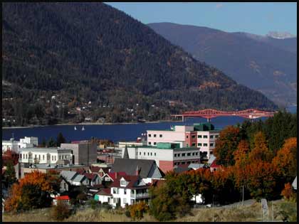
| The City of Nelson on the West Arm of Kootnay Lake. The city campground is pretty much behind the cluster of trees at right, affording beautiful views of lake and mountains. | ||||||||||||||||||||||||||||||||||||||||||||||||||||