


 |
|||||||||||||||||||||||||||||||||||||||||||||||||||||||||||
| Days 8 & 9: Nelson
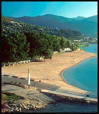
We spent these two days relaxing, showering, eating, swimming, walking, eating, relaxing, eating, swimming, eating and more eating. We walked along the roads bustling with summer activity and boasting bake shops, natural foods stores and restaurants, gift and antique stores. One of our favorite places to spend time was Lakeside Park - a big park with lots of grass and shade and a pretty amazing beach. We swam in the lake, played cards and picnicked on the shady grass. It was quite the relaxing little highlight of our trip - a time to recuperate and get prepared for the last leg of the journey. |
|||||||||||||||||||||||||||||||||||||||||||||||||||||||||||
 |
|||||||||||||||||||||||||||||||||||||||||||||||||||||||||||
 |
|||||||||||||||||||||||||||||||||||||||||||||||||||||||||||
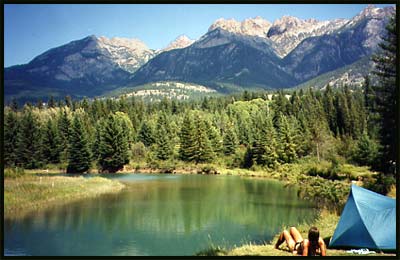
| Lakeside Park | |||||||||||||||||||||||||||||||||||||||||||||||||||||||||||
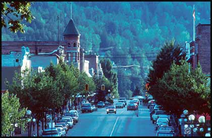
| Baker Street | |||||||||||||||||||||||||||||||||||||||||||||||||||||||||||
 |
|||||||||||||||||||||||||||||||||||||||||||||||||||||||||||
 |
|||||||||||||||||||||||||||||||||||||||||||||||||||||||||||
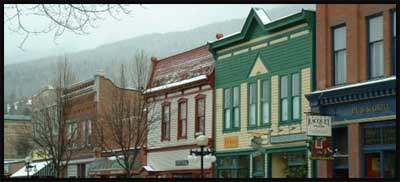
| Restored Nelson shop-fronts | |||||||||||||||||||||||||||||||||||||||||||||||||||||||||||
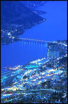
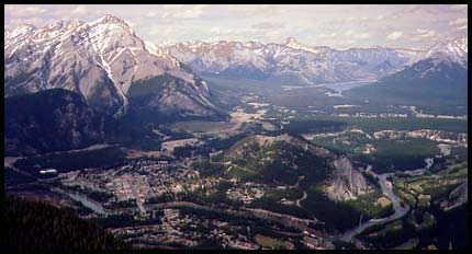
| Nelson and the West Arm of Kootnay Lake | |||||||||||||||||||||||||||||||||||||||||||||||||||||||||||
| Day 10: Nelson to Gray Creek
The second leg of the journey would take us from the Kootnays over to Kimberly and into the Rocky Mountain Trench. Travelling via paved road would have lengthened the distance considerably, instead we would travel over the infamous Gray Creek Pass. |
|||||||||||||||||||||||||||||||||||||||||||||||||||||||||||
 |
|||||||||||||||||||||||||||||||||||||||||||||||||||||||||||
|
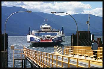
To set ourselves up for travelling over the pass in the early morning when it's much cooler, we had a short ride from Nelson north to the Balfour ferry that takes vehicles and passangers across Kootnay Lake. It's a very scenic 45 minute boat ride. |
|||||||||||||||||||||||||||||||||||||||||||||||||||||||||||
| The Balfour ferry coming into dock | |||||||||||||||||||||||||||||||||||||||||||||||||||||||||||
 |
|||||||||||||||||||||||||||||||||||||||||||||||||||||||||||
|
From the other side we had a short ride to a nice campsite located near the bottom of the pass - namely the Gray Creek Campsite. So, only 40 km's of easy riding this day, and another afternoon to rest up for the big day tomorrow. |
|||||||||||||||||||||||||||||||||||||||||||||||||||||||||||
 |
|||||||||||||||||||||||||||||||||||||||||||||||||||||||||||
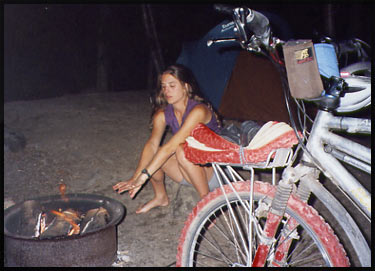
| Warming up by the fire in the standard-parks-issue fire drum | |||||||||||||||||||||||||||||||||||||||||||||||||||||||||||
| Day 11: Gray Creek to Cherry Creek
At 3am Andre woke me up, pointed out the mesh door of the tent to a structure across the campsite driveway from us and asked me what it was. I had not a clue. We both lay there for a good five minutes trying to figure it out - I thought maybe it was a rocket ship illuminated and ready for launch. But that somehow didn't seem right. We both gave up and went back to sleep. We got up at 4:30 and by that time the rocket ship had transformed itself into an outhouse. Much more useful at that point in time, too. We packed up and pushed off by 5:15 to tackle the steepest and longest mountain pass of our journey. |
|||||||||||||||||||||||||||||||||||||||||||||||||||||||||||
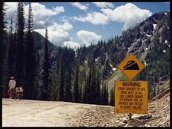
| And push we did. Step by step, 14 kilometers of steep up, up, up - much of it at 14% grade (which is steep on a fully loaded bike and a gravel road).
There were huge warning signs at the bottom of the road for vehicles to have proper ground clearance and low enough gears. Every so often a fully loaded logging truck would pass us, clouding us in thick dust for several minutes (we'd cover our faces with our shirts and wait it out). Four hours later we crested the pass only to find another sign warning of steep downhill grades for the next 14 kilometers. Boy, did we ever race down that road!! The legs got tired, having to hover above the seats so as not to get bounced off. The rear load kept shifting from the severe jolting, and once we had to stop and backtrack a few hundred yards to retrieve our folding saw! |
 |
||||||||||||||||||||||||||||||||||||||||||||||||||||||||||
| Gray Creek Pass. "Warning: Steep grades to 14% over next 14 km. Use lower gears. Excessive use of brakes may result in brake failure" | |||||||||||||||||||||||||||||||||||||||||||||||||||||||||||
| From the bottom of the pass it was still a good 40 km's on gravel to the short paved section before Kimberly. And the entire distance to Kimberly, about 50 km's was all a gradual uphill climb, in intense heat to top it off! The gravel road was tedious, winding back and forth (when it could have gone straight) with several sections of such coarse gravel we had to get off and push.
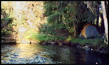
Finally we made it to Kimberly, but having no desire to camp at the "Happy Hans Kampground" as we had in 1994, we pushed on to a rest stop on the side of the highway about 10 km's out of town at Cherry Creek. As you can see in the photo at right, we barely had room to squeeze our tent in a tucked away area below the rest area (no camping allowed at rest stops). |
 |
||||||||||||||||||||||||||||||||||||||||||||||||||||||||||
| If you look close you can see me huddled in the tent, out of reach of the nasssssty mosquitoes. | |||||||||||||||||||||||||||||||||||||||||||||||||||||||||||
| The mosquitoes were horrendous, but not matter. We just set up camp, bathed in the icy pool next to the tent then climbed into the security of the tent's walls where we made dinner and played some cards before collapsing for the evening. | |||||||||||||||||||||||||||||||||||||||||||||||||||||||||||
| Day 12: Cherry Creek to Fairmont Hot Springs
Another early start this day to beat the heat and the traffic, now that we were on the main highway leading north through the Rocky Mountain Trench. Finally we were rewarded with long flat stretches and small, rolling hills and were able to make very good time. We arrived at Fairmont Hot Springs in the early afternoon and decided to camp and the large campsite along the Columbia River. We didn't go to the hot springs themselves, instead we relaxed at our river-front spot and plunged into the icy water of the river, over and over. |
|||||||||||||||||||||||||||||||||||||||||||||||||||||||||||
 |
|||||||||||||||||||||||||||||||||||||||||||||||||||||||||||
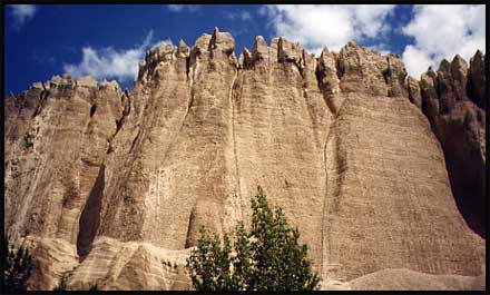
| Hoodoos looming above a narrow stretch of highway just before Fairmont Hot Springs | |||||||||||||||||||||||||||||||||||||||||||||||||||||||||||
 |
|||||||||||||||||||||||||||||||||||||||||||||||||||||||||||
 |
|||||||||||||||||||||||||||||||||||||||||||||||||||||||||||
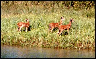
| Three fawns lived on a small island in the river across from our camp | |||||||||||||||||||||||||||||||||||||||||||||||||||||||||||
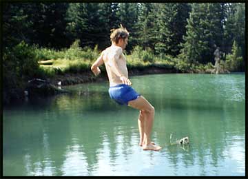
| Jumping into the headwaters of the mighty Columbia River | |||||||||||||||||||||||||||||||||||||||||||||||||||||||||||
 |
|||||||||||||||||||||||||||||||||||||||||||||||||||||||||||
 |
|||||||||||||||||||||||||||||||||||||||||||||||||||||||||||
| Relaxing at our river-side camp below the towering Rocky Mountains Click the photo to view a full size image | |||||||||||||||||||||||||||||||||||||||||||||||||||||||||||
| Day 13: Fairmont Hot Springs to Marble Canyon
We got up just after six and ate our breakfast in the tent where it was still warm and we had protection from the hordes of mosquitoes. We packed up as much as we could inside the tent, and once outside took the tent down, packed up the rest, loaded the bike (always a bit of a task) and were gone within 15 minutes! Riding north, we came to Radium Hot Springs where we had our last opportunity to buy groceries before Banff. The tiny grocery store didn't offer much, and most of the stuff we bought ended up being stale. We passed through the gates for Kootnay National Park and climbed the steep and winding 9 km Sinclair Pass, at the top of which a spectacular view of the Rocky Mountains and Kootnay River unfold before you. |
|||||||||||||||||||||||||||||||||||||||||||||||||||||||||||
 |
|||||||||||||||||||||||||||||||||||||||||||||||||||||||||||
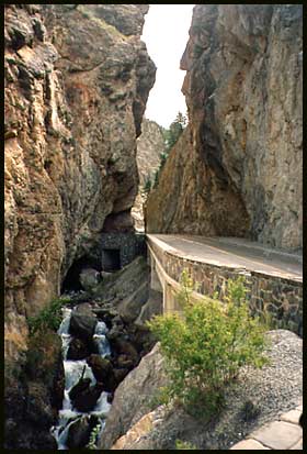
| The highway cuts through a narrow gorge in the Sinclair Canyon at the bottom of the pass, directly after the Parks booths | |||||||||||||||||||||||||||||||||||||||||||||||||||||||||||
 |
|||||||||||||||||||||||||||||||||||||||||||||||||||||||||||
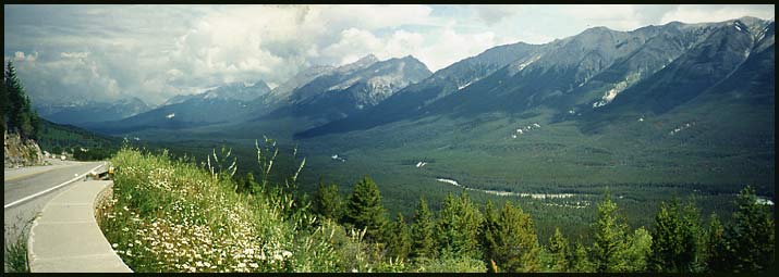
| The view of the Rocky Mountains towering above the Kootnay River from the top of Sinclair Pass | |||||||||||||||||||||||||||||||||||||||||||||||||||||||||||
 |
 |
||||||||||||||||||||||||||||||||||||||||||||||||||||||||||
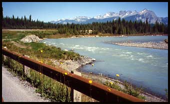
| Riding along the Kootnay River | |||||||||||||||||||||||||||||||||||||||||||||||||||||||||||
| We made camp that evening at the Marble Canyon Campsite, about 10 km's from the top of the Vermilion Pass. Along the way we met a group of three cyclists on their way down the pass - two German fellows on a Santana tandem pulling a Bob-trailer, and a girl, Catherine, travelling with them for part of the journey. We chatted with them for a while, and found out that Martin and Bernhard would be passing through Vancouver later in August. They were on a journey from Anchorage, Alaska to Death Valley, California. We invited them to visit us, which they did (they camped on the lawn for a couple nights), then met up with them again in Hollywood when we were there for a trade show in September. | |||||||||||||||||||||||||||||||||||||||||||||||||||||||||||
 |
|||||||||||||||||||||||||||||||||||||||||||||||||||||||||||
 |
|||||||||||||||||||||||||||||||||||||||||||||||||||||||||||
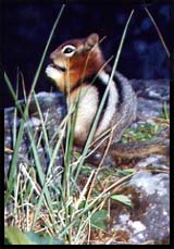
| A fearless little chipmunk posed for us at Marble Canyon | |||||||||||||||||||||||||||||||||||||||||||||||||||||||||||
| Catherine, Bernhard and I standing before their loaded bikes | |||||||||||||||||||||||||||||||||||||||||||||||||||||||||||
| Day 14: Marble Canyon to Banff
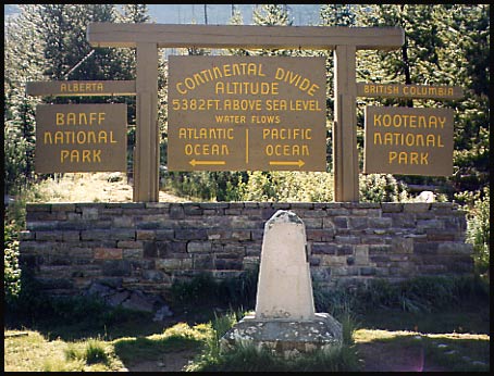
After a cold, cold night we got up at 6:00 am to find our water bottles frozen! Layering on as much clothing as we had, we packed up and began the last ascent of the bike trip to the top of the Vermilion Pass and the Continental Divide. |
|||||||||||||||||||||||||||||||||||||||||||||||||||||||||||
 |
|||||||||||||||||||||||||||||||||||||||||||||||||||||||||||
|
|||||||||||||||||||||||||||||||||||||||||||||||||||||||||||
 |
|||||||||||||||||||||||||||||||||||||||||||||||||||||||||||
 |
|||||||||||||||||||||||||||||||||||||||||||||||||||||||||||
| Where Highway 93 (the Vermilion Parkway) joins with Highway 1 (the Trans Canada) at Castle Junction, we got onto the less-travelled Bow Valley Parkway which parallels the #1 to within six kilometers of Banff. | |||||||||||||||||||||||||||||||||||||||||||||||||||||||||||
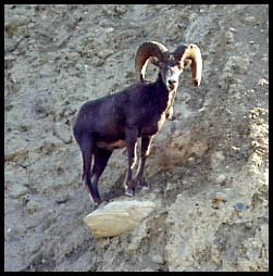
| This fellow gazed down at us from his perch not high above the road | |||||||||||||||||||||||||||||||||||||||||||||||||||||||||||
| Mt. Assiniboine, the "Matterhorn of the Rockies", looms above the Bow Valley Parkway | |||||||||||||||||||||||||||||||||||||||||||||||||||||||||||
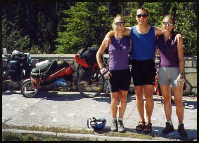
| WE MADE IT !! | |||||||||||||||||||||||||||||||||||||||||||||||||||||||||||
 |
|||||||||||||||||||||||||||||||||||||||||||||||||||||||||||
|
|||||||||||||||||||||||||||||||||||||||||||||||||||||||||||
| Banff of bust, here we were in Banff. Having spent some time here when we'd cycled here in 1994 and met with our friend Scott Dunbar for a hike in the Rockies we decided to just stay for lunch, then take a Greyhound Bus back to Vancouver. I'd also come down with a bad head cold and a chill, and was not in any mood to sight-see or camp another night or two.
We bought tickets for an afternoon departure, and began the task of dismantling the bike to fit it in two bike boxes which we spliced together. We arrived back in Vancouver at 4:00 am, where Ashley picked us up and took us back home. |
|||||||||||||||||||||||||||||||||||||||||||||||||||||||||||