|
|
|
|
|
|
 |
|
 |
|
| Day 4: Cottonwood Creek Camp to (almost) Avalanche Creek Camp
Our first morning awakening to clear, blue skies! Most of us were out of the tents by 7:00, but it was 10:00 before we were finally all ready to begin the fourth day's journey. Finding the proper route across Cottonwood Creek was a little difficult (apparently there's a cabel car now), but eventually we came to a few fallen logs over the creek with a make-shift railing.
|
|
|
 |
|
 |
|
|
|
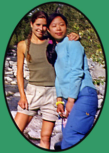
San 'n me at Cottonwood Creek |
|
|
|
| Crossing Cottonwood Creek. L-R: San, Stephan, Dan, Trudel, Reimar, Ken, Heidi and John at far right supporting the make-shift railing. |
|
|
| Once across we lost sight of any sign of a trail, but located a route west into the forest which led into a clearing where we discovered the displaced TeePees from day 1. Still no sign of a trail. Figuring the trail should lie north of us, Andre, Reimar, John and Ken split up and tramped north through the bush to try and intersect the trail. Shortly after, the rest of us heard shouts, and soon we were on our way once again. |
|
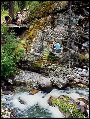
| Scudamore Creek Canyon Cable Crossing
We ascended a good hill, and about 3.5 km's further along became aware of the roar of water. Sure enough, we followed the trail around a bend and found ourselves above the impressively tall canyon of the roaring Scudamore Creek. Here was our second cable car crossing, taking us across the tall canyon in a much smaller carriage than the first one--you had to really squeeze to get yourself and a pack in. If I recall correctly, I believe the big guys went alone and two packs at a time went separately.
|
|
|
|
|
 |
|
 |
|
|
|
| Overlooking the canyon from the trail as Ken helps hoist me across in the tiny carriage |
|
| Flood plains, masses of windfall, cedar groves and armies of mosquitoes dominated the rolling terrain for 3.5 km's after the cable crossing. We crossed Grizzly Creek at 5:30, and using John's GPS determined that "Lookout Camp" was "only" about 4 km's further on, so we decided to get out of the dark forest and push on for what sounded like a fairly scenic camp.
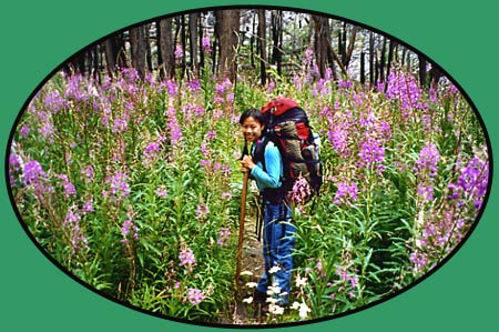
We quickly found ourselves hiking through a massive area burned by fire in 1996, where the only colour among the burn stumps came from the flowering purple fireweed reaching high above the heads of us shorter folk.
|
|
|
 |
|
|
|
| Ken, Andre and I stand on the opposite platform while San looks back anxiously: "Are you getting a picture of this, Dan??" |
|
| A Difficult Day
By 7:00 we were still no where near any camp when we began to ascend a long, steep hill. Heidi, Ken and I reached the top first and quickly assessed that this must have once served as "Lookout Camp", though there was hardly a patch of flat ground to be had. We feasted on berries while waiting for the others.
|
|
| Close to 8:00 we were ready to press on, anxious to find a place to camp as we hiked across one steep slope after the next, with nothing but dense bush below and burned trees rising on the steep slope above. About 9:00, when group morale was sinking to its lowest, I decided to scamper off the trail and up the steep hill and actually found a tinly "level" spot and a gully where we could hack out enough flat ground among the burned trees and fireweed for a few of the tents.
Leaving my pack, I ran down the hill and came across Reimar bushwhacking through thick shrubs--evidently he'd lost the trail! I went back to where San and Stephan were, and relieved exhausted San of her pack, carrying it up to camp for her as I showed them the way.
Once assembled in the gully, we worked frantically pulling up fireweed, kicking and stomping at the ground to flatten areas for the tents. Not all tents went up, as there was not much room and Heidi & Ken ended up doubling up in Ken's slightly roomier tent. John had already left to collect water, as there was none at camp, and Andre filled his arms with all our empty water bottles and bladders and left to join him.
At 10:00, now long dark, John returned with water, but Andre was nowhere in sight, nor had John even seen him. Reimar and I began shouting into the blackness, but no answer. Finally, twenty minutes later Andre returned with 13 litres of water!! He had run four km's back to the last creek we'd crossed, while John had bushwhacked down the the Stein (with no flashlight). Andre was exhausted, dehydrated and famished--he hadn't eaten anything since lunch. But, he was hailed like a hero having provided us with all the water we needed to cook and drink (John had "only" filled about 5 litres) and was thus waited upon hand and foot as he collapsed into the tent.
A small fire had been made, and after we'd eated we went about trying to clean as much of the sweat and grime off our sticky bodies before climbing into our bags. It was midnight by the time we were all tucked away and camp was quiet.
|
|
|
|
 |
|
|
|
|
|
|
| Day 5: (Almost) Avalance Creek Camp to Logjam Camp
We awoke at 8:00 AM to the sound no one wants to hear at halfway through a long hike; heavy rain. Finding our camp a soggy, dismal, burned-out mess, we ate breakfast in the tents before dressing in our wet-weather gear (for some of us Gore-Tex, for others a mere plastic cape) and packed away our gear and heavy, wet tents. At departure the rain let up, but the dense bush was of course still soaked.
|
|
|
|
 |
|
|
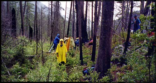
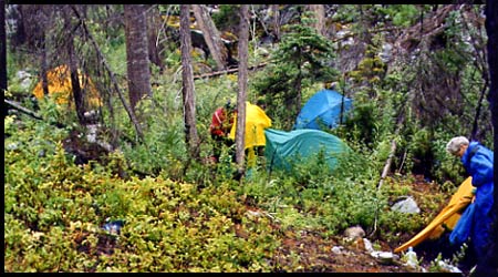
| John stands in the middle of our makeshift camp like a tall, sad yellow ghost whle Heidi and Ken pack up behind him. |
|
|
 |
|
|
|
Another view of our camp; Andre and my tent at left, Reimar and Joh packing up at center next to their green tent, San & Dan's blue tent behind, Heidi at far right. |
|
|
|
 |
|
| Not five minutes along the trail we came into the clean, dry and spacious "Avalance Creek Camp", next to Avalance Creek of course! Arrrgh -- next time we send a scout ahead, especially for water!
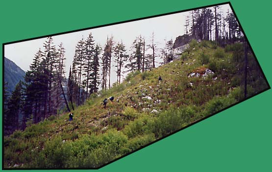
We hiked through patches of burned forest, large, messy clearings covered in fireweed and strewn boulders and ascended a rocky hill (right) to a viewpoint where we took a mid-morning break.
|
|
 |
|
|
|
|
|
|
|
| It somehow seemed fitting that the wettest day would see us hiking through the densest bush and muddiest terrain (even in dry weather). We broke for lunch inbetween showers, and shortly after the skies poured down the heaviest torrent yet. At 4:30 we came to a flat, open forest right next to the Stein River, wide and trianquil here, and the third and final cable car crossing. Deciding this was an excellent spot to camp, the men set right to work stringing up our one large tarp and building a roaring fire underneath.
The rain let up and even the sun came out, making the task of drying our wet gear a little easier.
|
|
| Casual John, always dressed like quite the gentleman, spends a few moments engrossed in "Constantine" |
|
|
 |
|
| Luckily most of the contents of our packs had ben stored in plastic, so not much other than what we were wearing was wet.
Nearby, at a large, pebbly beach at a bend in the river, Andre and I bathed in a deep, ice cold pool, implementing the "washing machine wash"; soap up, sink up to neck in water, spin back and forth violently and stagger out clean (and blue!). San sat on the beach near us, thinking the cold water might soothe her skin which had swolled over her entire body as an allergic reaction to the mosquitoe bites. She was almost in tears at the burning, itching pain, but back at camp Ken gave her some Noxema which helped tremendously. She was covered in Noxema for the rest of the trek!
|
|
|
|
|
|
|
|
|
|
|
|
| Day 6: Logjam Camp to Stein Lake
Our last day in the Stein Valley found us in good cheer and eager to cross the cable car and make for Stein Lake.
|
|
|
|
 |
|
|
|
|
|
 |
|
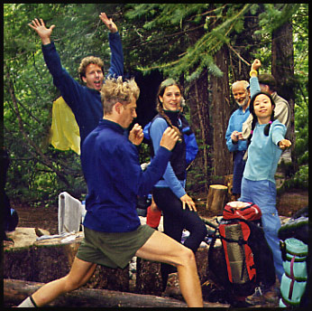
| Excitement fills the air as we prepare to leave our last camp in the Stein Valley |
|
|
 |
|
|
|
| After crossing the river, the trail was easy to follow throgh an open cedar forest with very little bush. After 2-3 km's we began to climb steadily, eventually comming out to a viewpoint where we could see down the Stein Valley, as well as up into the North Stein Valley and to a cascading waterfall of the North Stein. |
|
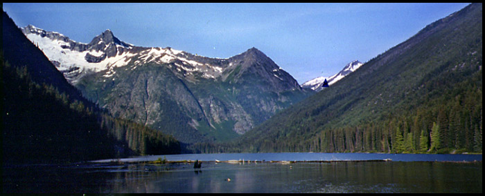
| Stein Lake
At 2:15 we enjoyed the "monumental" satisfaction of having arrived at Stein Lake. The fairly easy 6km hike of this day under clear skies gave us a sense that we hadn't even dome much this day. None-the-less, we decided to stay put and camp for the day to regain as much strength as we could to prepare for the demanding 3,600 foot ascent that would take us from Stein Lake up to the alpine in one long, arduous climb tomorrow.
|
|
|
|
|
 |
|
|
|
| Stein Lake. Our camp was at far left of this photo (above the 'S' in 'Stein Lake'. The triangle just right of center marks the steep slope we would be clambering along on day 8, on our way to Figure 8 Lake. The peak above the triangle to the right is Caltha Peak, which looms over Tundra Lake. |
|
|
|
|
|
|
|
 |
|
|
|
|
|
|
|
|
|
|
|
|
|
 |
|
 |
 |
 |
 |
 |
|
 |
|
|
|
|
|
|
|
|
|
|
|
|
|
|
|
|
|
|
|
|
|
|
|
|
|
|
|
|
|
|
|
|
|
|
|
|
|
|
|
|
|
|
|
|
|
|
|
|
|
|
|
|
|
|


