|
|
 |
|
|
|
 |
|
| Day 9: Figure 8 Lake to Heart Lake
I awoke at 5 AM and opened the door of the tent to have a look at the weather and found nothing but a thick, white wall. Knowing we would have to stay put if the white-out continued, I anxiously went back to sleep.
Awaking to stirrings of others in the group, I poked my head out once again at 8:00 and was this time greeted by crystal clear blue skies.
Tired and groggy from the previous day, none of us was in any particular hurry to pack up and move on. Especially considering the spectacular setting we now found ourselves in. The landscape surrounding us was a complete surprise, as we'd arrived in thick white-out.
|
|
|
 |
|
|
|
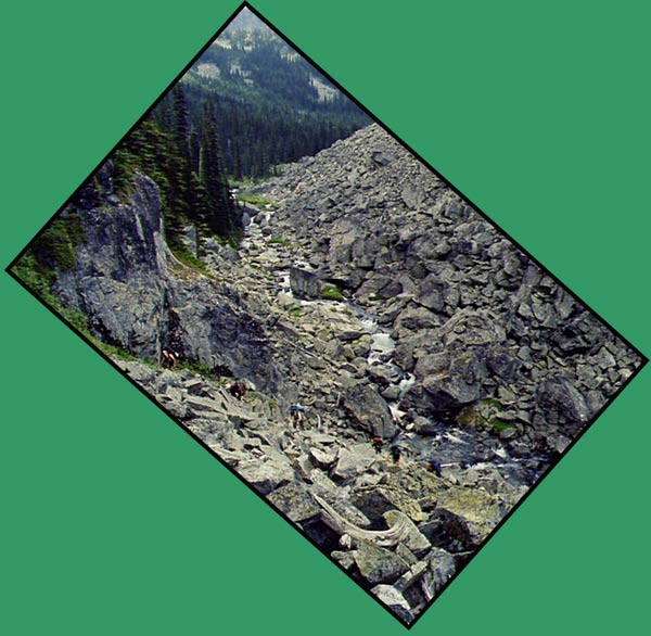
This photo shows the rockslide we crossed the previous evening. We began at the far right of the photo, made our way across the slide area below the cliffs at the top, and descended at left. |
|
|
|
 |
|
|
|
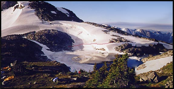
Figure 8 Lake and camp (at far left). You can see how part of the lake is still covered in snow. The dotted red line shows where we carefully crossed the snow to join with the main trail at the opposite end of the lake. |
|
|
| Late morning we pushed onward, crossing the snow above Figure 8, arriving at the camp on the other side but finding it deserted. The six people camped there had gone for a day hike, but we left a note by their tents thanking them for their help in getting John across last night.
We met up with the trail, the most well-worn trail we'd set food on since day 1!
Skies were blue, the terrain easy and the scenery absolutely out of this world!
The trail leads along the mountainside high above the glacially-eroded U-shaped Roger's Creek Valley to Caltha Lake, a very unusually coloured lake, with Tundra Peak looming, almost ominously, in the distance.
|
|
 |
|
|
|
This Inukshuk (man-shaped cairn) marks the trail at Figure 8 Lake. Note the well-worn trail just to the left of the cairn. |
|
|
|
Caltha Lake and Tundra Peak |
|
|
|
 |
|
|
|
Another odd-shaped photo, this time 2 spliced together. The shorter route to Tundra Lake follows the left side of the lake to the low saddle, directly on the other side of which lies the lake. Tundra Peak looms in the distance, now under sunny skies as opposed to the dark, ominous skies of the previous day. |
|
|
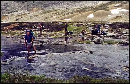
| The outflow of Caltha Lake needed to be crossed, so it was off with the boots as there was no good place to rock hop to the other side. |
 |
|
|
|
Crossing Caltha Lake's outflow. L-R: Trudel, Heidi (watching, not too keen to follow!), Dan, Andre (removing boots), Stephan (rumaging for food!) |
|
|
 |
Once across, we spread out the tarp and had an extended lunch break on the soggy meadow. After the meal, we all lay down, except Andre, who surveyed the trail up Cherry Pip Pass with his telescope and a short stretch on foot. (Does anyone know where that ridiculous name for a pass came from??)
Coming back to us, he said it looked erie seeing all of us scattered motionless on our backs across the meadow!
|
|
|
|
View of Caltha Lake and Peak from Cherry Pip Pass |
|
|
| Once we climbed Cherry Pip Pass, which was no small feat, we traversed the rock and snow of Tabletop Mtn., the whole time wondering where the trail would begin its long descent to the Lizzie Lake drainage. Just when we were really beginning to wonder, the trail snaked around the corner of the rugged mountain giving us a view of a valley just dropping away from our feet. The trail snaked its way down, down, down--extremely steep. We were sure glad we didn't begin the trip with our heavy packs having to ascend this!
Soon, the small, rocky plateau holding Heart and Arrowhead Lakes came into view, and we decided to make camp at Heart Lake (below).
|
|
|
|
 |
|
|
|
View of Heart Lake as we approach. We camped just above it, on the right. |
|
|
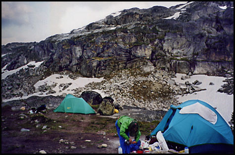
| Our camp at Heart Lake was our coldest camp of the journey. Surrounded in rock, cliffs, small lakes, tarns and snow, the place was even cold (though spectacular) to look at. Not having washed since day 6 at Stein Lake, a few of us were eager to get three days grime off our skin. There was a small tarn just hidden from our camp where we washed, its virtually glacial water illiciting screams from some of us! |
|
|
 |
|
|
|
Our cold, rocky camp at Heart Lake. |
|
|
|
 |
|
|
|
|
|
| Day 10: Heart Lake to Lizzie Lake Trail Head
Our last day arrived with mixed feelings; we all felt anxious and excited about finishing the trek, yet there was an underlying sense of sadness that our wonderful adventure was drawing to a close. After slowly packing up camp, we hiked in the sunshine down to the side of Arrowhead Lake where Ken set up his camera on a rock for a group photo.
|
|
|
|
 |
|
|
|
The Stein crew at Arrowhead Lake. L-R: John, Dan, Stephan, San, Heidi, Trudel, Andre, Ken, Reimar. |
|
|
|
The Lizzie Cabin |
|
|
| After a steep descent from Arrowhead Lake through bush and over muddy ground, we once again found ourselves in a forest of tall trees, this time in the humid, coastal climate as opposed to the dry climate of the interior.
We came to the Lizzie cabin, a quaint log structure in the middle of the woods, complete with three sleeping hikers!
|
|
 |
|
|
| "The Gates of Shangri-la" |
|
|
 |
Following the drainage of Lizzie Creek, we soon had to climb up, over and along the vast rock slide referred to in the guide book as "The Gates of Shangri-La".
By now, we were seasoned rock-traversers, and scampered along with great comfort and ease (I'm sure 20 lbs of food out of most of our packs made quite a difference. My pack was under 30 lbs by this time, having begun with 50--close to half my weight of 110 pounds!)
|
|
|
| We are mere specks among the boulders as we climb the rock slide. Pictured left to right, (if you can spot us!) are: Heidi, Reimar, John, San, Trudel and Andre |
|
|
|
We Made It!! |
|
|
 |
|
|
|
A final group photo at the Lizzie Lake campsite. Tired and a little beat-up looking compared to the fresh and sprightly crew of 10 days ago, but no worse for the wear! |
|
|
| Now it was time for another long shuttle. First, a shuttle down to Lilloet Lake, then John, Dan, Andre, San and I drove three hours back to Lytton to drop off John and retreive Dan and Reimar's vehicles. It was evening before we returned and midnight before we were home.
A glorious and memorable journey it was!!
|
|
|
| Stein Valley Reunion: October 18, 2001 |
|
|
|
 |
|
|
|
We're so clean and shiny, you may need to put on sunglasses!! And because we're no longer recognizable, we are: L-R: Ken, Heidi, Andre, Stephan, Trudel, Reimar, San, Dan w/ Ernie |
|
| Three months pass and we re-assemble as a group (minus John but plus Ernie) to share memories and photos! Well-showered, well-rested and well-fed, we are barely recognizable as the crew that traversed the Stein.
A wonderful trek it was, and a wonderful group of people!!
|
|
|
|
 |
|
|
 |
|
|
|
 |
|
 |
|
 |
|
 |
|
 |
|
|
 |
|
|
|
|
|
|
|
|
|
|
|
|
|
|
|
|
|
|
|
|
|
|
|
|
|
|
|
|
|
|
|
|
|
|
|
|
|
|
|
|
|
|
|
|
|
|
|
|
|
|
|
|
|
|
|
|
|
|
|
|
|
|
|
|


