|
|
|
|
 |
|
 |
|
| Day 7: Stein Lake to Alpine Camp
An early start this morning; out of the tents by 6:00 and across the logjam to the other side by 8:00. The trail skirted roughly toward the outflow, past a large waterfall, immideately thereafter it angled to the left taking us up a near vertical climb of over 3,000 feet. The angle is so steep (no switchbacks either; the ridge is too narrow) that in most places when you stand straight up the slope is only a foot away from your nose.
|
|
|
|
|
|
 |
|
|
|
|
|
| Needless to say, at this rate we gained elevation extremely quickly. As on any major ascent, age and fitness are a big factor on pace and endurance. Though our group ranged in ages from 15 to 68 and in varying degrees of fitness, we did extremely well. I believe attitude has more to do with ability than age or fitness.
Once most of the elevation had been gained, the route became more difficult to find as it began sidehilling along and below steep and treacherous cliffs. All we could do was locate one vague tree marker, then the next and son on, working our way along gradually, making sure we didn't sway from the route. This slowed our progress, making an easier pace and keeping the group tightly together.
The views were worth every ounce of struggle and sweat. Stein Lake lay directly below us, Mount Klackarpun rising steeply above with the basin of spectacular Elton Lake visible, its waterfall cascading hundreds of meters.
|
|
|
|
 |
|
|
|
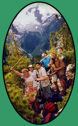
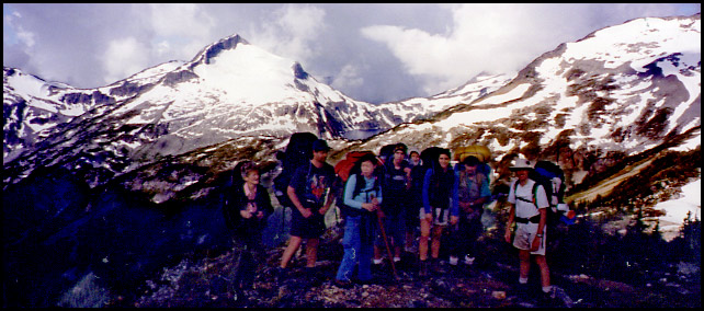
| Taking a break, Mount Klackarpun behind. Looks like that mountain air is having its effects on Dan... |
|
| Slow Progress
After what seemed like hours of climbing a torturous route, we found ourselves on a very distinct saddle. It was not clear where the route continued, so as Ken and I waited for the others, I quickly dropped my pack and scampered up a narrow, rocky spine to its peak above a terrifying precipice to see if the trail climbed this route. Fortunately it didn't.
As the others gathered, Andre managed to discover that the trail continued sidehilling, though just below us. Eventually the markers and route became more clear as it slowly led us to the open alpine ridge.
|
|
|
|
| Sidehilling before the final ascent. Dan, San & Reimar in foreground, and barely visible as small specs just left of the tall tree at center are Stephan, John, Heidi, Ken and myself. |
|
|
 |
|
| Finally we begin a more gentle ascent over an open, high alpine ridge, the U-shaped Stein Valley far below. Elevation is about 7,000 feet (~2,100 meters). L-R: Stephan, Heidi, Ken, Trudel. John, Reimar and San are the tiny specs behind. |
|
| It became quite clear that in no way were we going to make it to Tundra Lake this day as originally planned. The ridge is very narrow in places, so at 4:00 we made camp where we had opportunity on a wide, flat area. Completely exposed to the elements, we strung up the tarp between some small trees just in case, and used lengths of rope tied around our tents and secured with large rocks against the wind. |
|
|
|
 |
|
|
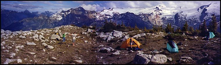
| Our alpine camp at 2,100 meters. Stephan stands left of center, arms wide taking in the expansive beauty, San stands just next to him. Trudel stands infront of her tent, Stephan's tent just to the right and Reimar, though only a black dot with a white hat, stands infront of his tent at far right. |
|
| Vast cumulus clouds gathered around the surrounding mountain peaks, and whenever the sun disappeared behind a cloud the temperature immidiately plummeted. At sundown we piled on our warm clothing and huddled around a tiny fire in a slight hollow, which offered a bit of protection from the wind. |
|
|
|
|
 |
|
|
|
|
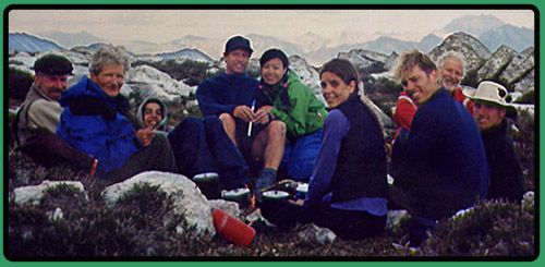
| Tired and hungry, we huddle around our tiny fire while Dan provided some entertainment with his penny whistle. Notice the three identical cookposts (lightweight titanium...)! |
|
|
 |
|
|
|
|
|
| Day 8: Alpine Camp to Figure 8 Lake
After a night of showers and strange creatures sounding on the ridge, we awoke to crystal clear skies and rose early at 6:00 AM once again.
|
|
|
|
 |
|
| We hiked along the ridge, up and down and up again towards Tundra Lake. In some areas the ridge was quite wide, in others only a narrow spine a few feet wide.
Tundra Lake
After a couple hours we spotted a large lake in the distance, hemmed in by mounains of rock and snow. Suddenly we realized it was Tundra Lake ---yikes! There were supposedly two routes
|
|
|
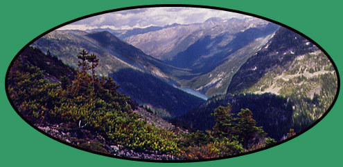
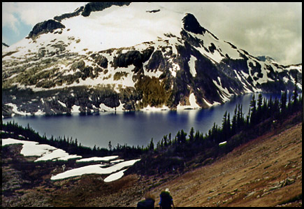
Stein Lake and valley from the ridge en route to Tundra Lake |
|
|
|
|
|
| leading beyond the lake to the LIzzie trail head; a shorter route, and the one we originally planned to take, along its shores and over the low saddle to Caltha Lake (in photo, above Tundra Lake), and a much longer route around the side of Caltha Peak eventually leading to Figure 8 Lake, then back to Caltha Lake on the other side of Caltha Peak.
From our current vantage point, neither looked possible, never mind even getting to the lake itself.
|
|
|
 |
|
|
|
A group portrait (minus Andre) with our first view of Tundra Lake. Caltha Peak looms above the lake at left. The route to Fig. 8 Lake runs below the large snowfield on Caltha; the route to Caltha Lake is via the shoreline opposite Caltha Peak and over the low saddle at the end of Tundra Lake. L-R: Heidi, Dan, Stephan, Reimar, Trudel, John, Ken |
|
|
| From the ridge we descended a treacherous slope to the meadows below, which we would traverse and ascend to gain Tundra Lake.
On hindsight, we should have left the ridge earlier and climbed down through easier meadows; the route we took was rather dangerous and we had to descend one by one, holding onto heather branches on the loose soil and rock. Once at the bottom, we had to clear away from the chute and the hazards of falling rock loosened by the next person comming down.
From the meadow, reaching the lake was quite easy. It was still a question in all our minds how we would get further past the lake.
|
|
 |
|
|
|
|
|
Arriving at Tundra Lake, Caltha Peak looming above (and cropped off by the brilliant photographer) |
|
|
 |
|
|
|
|
 |
|
| Dan says, "Where do we go from here??". As you can see, the right-hand shore looks a little steep and loose from this angle. (We have since learned that it is actually a relatively easy route) |
|
|
| The situatuation was certainly not aided by the dark, cold clouds hanging overhead and the chill, icy wind. At 2:00 we found shelter at the camping area above the lake and settled into some lunch. Andre took his telescope and left to survey our route options. He ran to the south end of the lake, just below Caltha Peak, while I looked over topo maps with Heidi and Ken. When Andre returned, we decided we should opt for the longer route to Figure 8 Lake, and if we were going to get there today to leave right away. |
|
|
 |
|
|
|
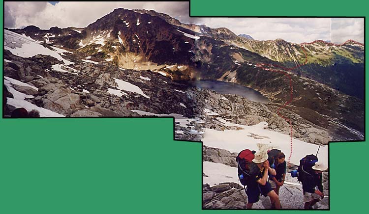
Yes, it's an odd-shaped photo. It's actually three spliced together. The red dots roughly show our route from the ridge. Reimar is cupping his hands to yell for John who is by now out of sight. |
|
|
| From Bad to Worse
This is where things got a little.....tense. Andre forgot his maps and compass at Tundra Lake. Upon leaving the lake the group became separated. John forged ahead his own way by himself. Dan and Sephan were up ahead, but at least scouting an easier route. Ken, Reimar and Heidi were a ways behind Dan and Stephan, but far ahead of Andre, San and myself. After I had a bit of a fit, the others, except John who was out of ear shot, waited and we re-grouped. By now John was completely out of sight.
We only realized the maps and compass were missing two hours past the lake when we stopped to consult them. Now the only remaining means of navigation were Andre's telescope and John's photocopied map and his GPS. But where was John??
We continued along and soon the rocky slope turned to a grassy, treed hillside where we could follow a clearly marked route. But not for long. At the edge of the trees we were faced with crossing a steep cauldron of rock, over a kilometer long. Steep cliffs hung above and below, while several snow chutes covered the rocky slope from top to bottom. Andre took out his telescope and scanned the area for any signs of rock cairns. Sure enough, on the distant saddle behind which we believed Figure 8 Lake to lie, he spotted a definite man-made sculpture.
With nowhere else to go, we met up with John, then began the arduous crossing.
|
|
|
 |
|
|
|
|
|
 |
|
|
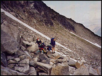
Check out the size of these boulders we had to clamber around! This cluster of people is comprised of Reimar, San, Stephan, Trudel and Andre. |
|
|
Andre and Dan anchor the rope (around a rock) on one end while I slowly walk across. |
|
|
|
| Crossing the Boulder Field
We slowly and carefully made our way across the boulder field and four snow chutes, using a rope anchored on both ends as an anchor point of safety while crossing. The snow chutes drop down to the edge of a cliff, and then into sheer nothingness until the valley several thousand feet below. The guidebook warns to "exercise due caution when crossing the snow fields on account of fatal results below". No kidding.
|
|
| As we neared the end of the vast rock slide, we had to make a choice of two possible locations of Figure 8 Lake. With no map on us, we had to rely on John's map, but once again he had gone quite a distance ahead of us. He was making his way for the higher, much higher, saddle which lies just beneath Caltha Peak. Andre set down his pack, and had us wait while he climbed the steep slope to reach John.
It took him twenty minutes just to catch him!! The two men climbed to the top of the saddle together--there was no lake visible as the map showed it to be. Andre took one look at the map and deduced right away that we should be making for the lower saddle. With night comming and seven cold people left far below, he ran back down to us, leaving John who refused to descend, believing the high saddle to hold Figure 8 Lake.
|
|
|
|
|
|
 |
|
|
Heidi and San follow Andre past the cairn he'd spotted with his telescope from a kilometer away |
|
| As we hiked to the low saddle and onto the heather fields beyond, a thick cloud of white-out blew over us. We arrived at Figure 8 Lake about 9 PM, seven hours after we'd left Tundra Lake, only 2.5 km's away.
Fear at Figure 8 Lake
We quickly set up our tents in a protected, windsheltered area while Andre went about making us a fire. Reimar and Ken shared Ken's tent, as John had the body to the tent the two men had been sharing. We were all quite shaken up and concerned about John. It was almost dark and virtually zero visibility.
As we huddled around the fire, we heard a distant whistle sound out of the fog. Andre jumped up and ran to the edge of the snow pack at the side of the lake and tried to communicate with whom we believed to be John. How did he get to the other side of the lake?? Andre made voice contact--it was John. But then he heard John shout something like, "I can't ----- any longer!!", then lost communication with him.
|
|
|
|
 |
|
|
|
|
| Photo of Figure 8 Lake, taken on day 9 by Heidi. The snowfield at left above the lake is the route to the other side where the main trail begins once again. Day 9 would also find us walking below the snowy peaks at center. |
|
|
Unable to get another response from John, Andre yelled to us, "He's gone! I've lost him! I think he's drowned in the lake!" The steep snow pack lay directly over the water, which was frozen at that end. If someone were to slip, they would quickly slide into the lake unless they had an ice pick.
Like out of a move, we heard a woman's voice, distant but clear, shouting over and over from the opposite end of the lake, "He's okay! He's okay!" We tried to shout back to her, but the wind was howling too strong, it would carry her voice to us but not ours back to her. At least we knew John was safe.
About fifteen minutes later, the fog lifted just a little and we spotted three shapes making their way across the snowfield just above the lake. At the edge of the snow, one continued up to us while the other two went back.
John had descended from the high saddle and eventually come upon the well-travelled trail leading between Fig. 8 Lake and Caltha Lake. He went left, to Figure 8 and at the lake came across a party of six camped on that end of the lake. They told him to follow their footprints to the opposite end of the lake, he would likely find us camped there. He followed their tracks, but they led to a precipice. He couldn't go any further, so turned back to their camp. They realized he was following tracks to where they'd made photos earlier in the day, so two fellows led him across to us.
And so, a long and anxious day came to a safe end after all.
|
|
|
|
|
|
|
|
|
 |
|
|
|
|
|
|
|
|
|
|
|
|
|
|
|
 |
|
 |
 |
 |
 |
 |
|
 |
|
|
|
|
|
|
|
|
|
|
|
|
|
|
|
|
|
|
|
|
|
|
|
|
|
|
|
|
|
|
|
|
|
|
|
|
|
|
|
|
|
|
|
|
|
|
|
|
|
|
|
|
|
|
|
|
|
|


